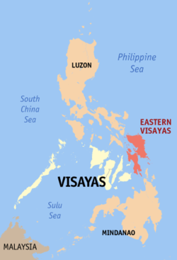
Eastern Visayas (Filipino: Silangang Kabisayaan) is one of the 17 regions of the Philippines, designated as Region VIII. It is composed of two main islands, Leyte and Samar, connected by the San Juanico Bridge, as well as Biliran Island, and consists of six provinces and seven cities,[2]namely, Biliran, Eastern Samar, Leyte, Northern Samar, Samar, Southern Leyte, the cities of Ormoc City, Baybay City, Maasin City, Calbayog City, Catbalogan City, Borongan City and the highly-urbanized city of Tacloban, the regional center. These provinces and cities occupy the easternmost islands of Visayas. It is one of only two regions having no land border with another region, MIMAROPA being the other.
Eastern Visayas directly faces the Pacific Ocean. The land area of the region is 2,156,285 hectares. As of 2010, it has a population of 4,101,322 people.[1]
Eastern Visayas lies on the east central part of the Philippines archipelago. It is composed of two main islands, Leyte and Samar, which formed the eastern most coast of the archipelago. It is bounded by Philippine sea on the east and north with San Bernardo Strait separating Samar island from southeastern Luzon: Camotes sea and Visayas sea on the west: Bohol sea on the south with Surigao Strait separating Leyte island from northwestern Mindanao. It has a total land area of 2,156,285 hectares or 7.2% of the country’s total land area.[3] 52% of its total land area are classified as forestland and 48% as alienable and disposable land.
Climate[edit source]
There are two types of climate prevailing in the region under the Corona system of classification: Type II and Type IV. Type II climate is characterizes by having no dry season but a pronounced maximum rainfall from November to January. Samar Island and the eastern part of Leyte Island fall under this type of climate. Type IV on the other hand has an even distribution of rainfall the year round and a short period of dry season that can be observed starting February up to May. This type of climate is well exhibited the western half of Leyte island and some portion of Samar which covers the municipality of Motiong up to San Isidro of Northern Samar.
Natural Resources[edit source]
The region's sea and inland waters are rich sources of salt and fresh water fish and other marine products. It is one of the fish exporting regions of the country. There are substantial forest reserves in the interiors of the islands. Its mineral deposits include chromite, uranium(in Samar), gold, silver, manganese, magnesium, bronze, nickel, clay, coal, limestone, pyrite and sand and gravel. It has abundant geothermal energy and water resources to support the needs of medium and heavy industries.
No comments:
Post a Comment